
ARC-LandingTM
Resilient localisation for Uncrewed Aerial Systems (UAS) is vital if they are to complete their mission when satellite navigation systems are temporarily unavailable, occluded by buildings, or have been actively blocked.
A last mile resupply air (or ground) vehicle can locate the endpoint of a mission within centimetres, without the need for satellite positioning at either end, or intercommunication, if the landing position has a Sensoriis ARCTM radar.
This proprietary and patented technology, known as Active Radar Cooperating or ARCTM, provides a localisation capability based upon direct radar range measurement, that is independent of satellites and resilient to jamming mechanisms.
The micro radar has no moving parts and has fully electronically controlled antennas arrays in a low Size Weight and Power package suitable for battery power. Radar is largely unaffected by poor visibility, lighting, and bad weather, unlike camera-based localisation.
Our Active Radar Cooperating (ARCTM) technology can support resilient, multilateration positioning capability, and autonomy for the UAS during the critical approach and landing phases, whether onto a fixed landing pad or onto a moving vessel. The micro radar installed onto any UAS can locate the UAS in 3D relative to the pad for autonomous landing.
Automation removes the need for highly skilled drone pilots and hence greatly reduces operational costs, such as in the case of offshore windfarm maintenance and ship-to-shore or port-to-ship flight missions. Our radar system also enables critical military logistics to take place, ensuring that the key assets reach their destination.
The ARC-LandingTM includes an ARCTM Primary radar installed on the UAS which reports the range, bearing, elevation and power to other ARCTM Secondary radars on or around the landing zone, whilst ignoring radar reflections from background infrastructure.
The total requirement for the number of secondary radars on the ground will be dependent on factors including whether the landing zone is located on fixed ground or a moving vehicle (on land, or sea).
Image 1: Typical UAS flight path during landing (side view)
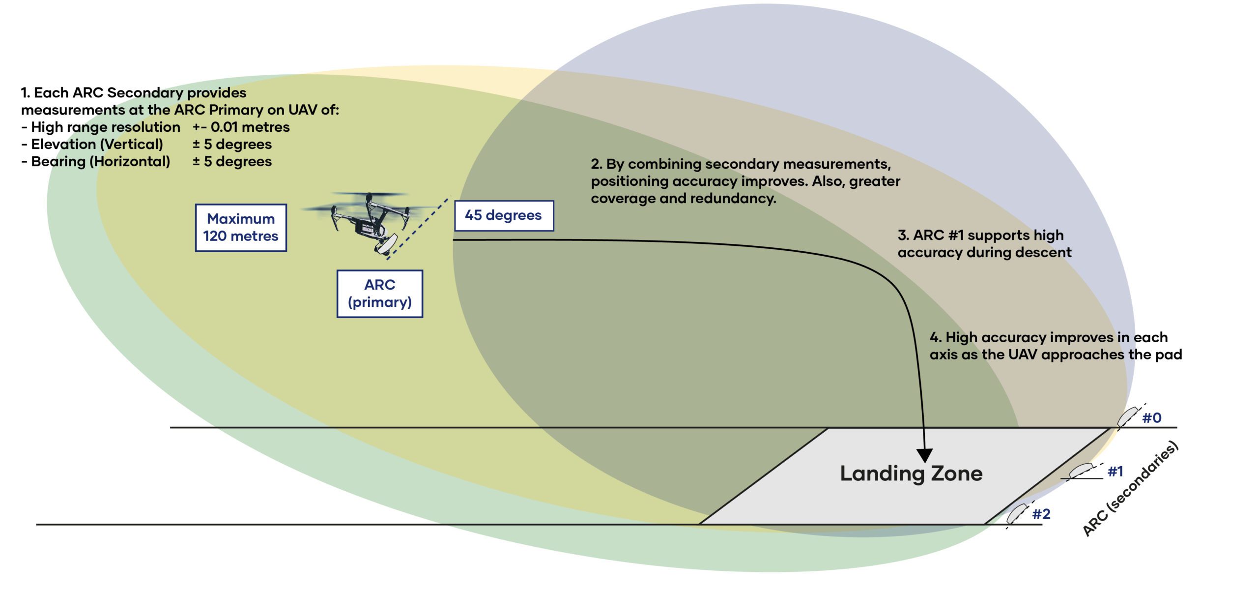
Currently we have a maximum detection distance of 120 metres, however, recent work has ensured we have extended range up to 1,000 metres.
The measurement accuracy is within 1 centimetre with up to 120-degree field of view in the horizontal and 90-degree field of view in the vertical axis. The dimensions of the ARCTM secondary radar on the landing zone is 120 x 120 x 45mm (<300 grams) and then we offer a smaller, lighter 30-gram form-factor for approved OEMs for the ARCTM primary radar which is installed onto the UAS.
Sensoriis provides radar-based precision positional information via the MavLink Precision Landing protocol that can be automatically consumed and enacted by MavLink compatible flight controllers, such as ArduPilot.
ARC-LandingTM can be used in conjunction with RadarAwareTM, our micro radar, which enables a UAS to detect objects in the flight path, supporting the safe operation of UAS in and around wind turbines for example, or infrastructure as they are surveyed.
It provides collision avoidance measurements in all weather conditions and minimises costly damage to turbines and other high-value assets, minimising time offline as well as providing peace of mind to the asset owners.
ARC-LandingTM also facilitates the automation of a UAS landing onto a pad, such as in the case of a vertiport. The ARCTM primary radar installed onto any UAS can be accurately localised in 3D relative to the ARCTM secondary radars on a landing zone for autonomous landing.